
- Home
- Artist
- Andy Warhol (98)
- Banksy (341)
- Chuck Sperry (15)
- Cocomilla (27)
- Damien Hirst (84)
- Dface (22)
- Invader (30)
- Kaws (52)
- Keith Haring (30)
- Laurent Durieux (24)
- Martin Whatson (30)
- Modern & Luxury (21)
- Pablo Picasso (63)
- Roy Lichtenstein (19)
- Shepard Fairey (92)
- Space Invader (22)
- Takashi Murakami (48)
- Thomas Kinkade (25)
- Tyler Stout (16)
- Unknown (144)
- Other (3704)
- Features
- 1st Edition (14)
- Adjustable Strap (16)
- Autographed (5)
- Embossed (10)
- Framed (372)
- Framed, Matted (6)
- Framed, Personalized (11)
- Framed, Signed (12)
- Impact Resistant (5)
- Limited Edition (111)
- Matted (21)
- Matted, Signed (19)
- Mounted, Signed (8)
- Numbered (68)
- One Of A Kind (ooak) (24)
- Personalized (8)
- Ready To Hang (7)
- Signed (745)
- Unframed (20)
- Unsigned (11)
- Other (3414)
- Framing
- Material
- Acrylglass (14)
- Acrylic (9)
- Canvas (317)
- Canvas Giclee Print (62)
- Canvas, Paper (15)
- Color Plate (16)
- Etching (8)
- Giclee & Iris (15)
- Glass (50)
- Gloss Paper (72)
- Leather (14)
- Lithograph (27)
- Matte Paper (21)
- Offset Lithograph (46)
- Paper (228)
- Paper Or Canvas (17)
- Papier (39)
- Pine (10)
- Print (30)
- Saffiano Leather (8)
- Other (3889)
- Subject
- Abstract (127)
- Abstract Art (52)
- Aircraft (19)
- Animals (43)
- Birds (26)
- Boxing (30)
- Dismaland (19)
- Fantasy (41)
- Figures (43)
- Figures & Portraits (48)
- Landscape (74)
- Love (25)
- Military & Political (20)
- Movies (58)
- Nudes (24)
- Politics (23)
- Portrait (52)
- Street Art (130)
- Vogue (24)
- Women (18)
- Other (4011)
- Type
- Canvas (20)
- Canvas Picture (6)
- Canvas Print (61)
- Comic Book (2)
- Engraving (4)
- Etching (3)
- Framed Print (3)
- Framed Prints (7)
- Lithograph (14)
- Photograph (3)
- Picture / Print (57)
- Poster (43)
- Print (1433)
- Prints (3)
- Skateboard (3)
- Stretcher Bars (2)
- T-shirt (3)
- Vintage Art Print (3)
- Wall Art (64)
- Wall Mirror (6)
- Other (3167)
Restored Antique Victorian Map Of The River Thames

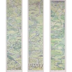


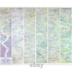
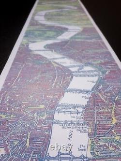
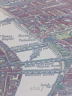

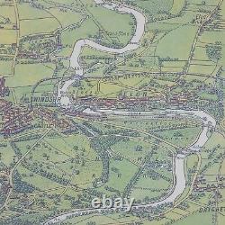



A print of a lovingly-restored Victorian strip map that follows the meanderings of the River Thames from London to Oxford in circa 1890. Each intricate feature has been delicately hand painted: the in-construction Tower Bridge in London; the smoke plumes of passing steam engines; and the forgotten green fields and trees surrounding familiar areas such as Battersea, Windsor and Henley. The six-panelled map follows the Thames' journey along English landmarks - before concluding above the rooftops of 19th century Oxford. Meticulously restored over the course of a year, the attention to detail is exquisite - remaining true to the original Victorian print from which the British artist was inspired. The map consists of six separate 150mm x 700mm sections.
Previous customers have displayed the prints in a number of ways: utilising included tabs to affix sections together in pairs, threes, or as one 4.2m feature; in single sections escalating along staircases; or framed side-by-side. One couple have even placed it on its side to create a freeze in their home office! This is a unique product to be treasured by anyone who knows and loves the familiar sights of the Thames, a passion for Victorian history and British heritage, or an appreciation for handcrafted historic cartography. Originally created before the Wright Brothers took to the skies by G. Bacon as an aid to navigation, it's a wonderful piece of Victorian ingenuity and artistic creativity that can be admired by all. This item is in the category "Art\Art Prints". The seller is "dayveid" and is located in this country: GB. This item can be shipped worldwide.Llewelyn

