
- Home
- Artist
- Andy Warhol (98)
- Banksy (341)
- Cocomilla (27)
- Damien Hirst (84)
- Dface (22)
- Invader (30)
- James Jean (15)
- Kaws (52)
- Keith Haring (30)
- Laurent Durieux (24)
- Martin Whatson (30)
- Modern & Luxury (21)
- Pablo Picasso (63)
- Roy Lichtenstein (19)
- Shepard Fairey (92)
- Space Invader (22)
- Takashi Murakami (48)
- Thomas Kinkade (25)
- Tyler Stout (16)
- Unknown (145)
- Other (3706)
- Framing
- Medium
- Acrylic (9)
- Canvas (7)
- Canvas Giclee Print (131)
- Canvas Print (5)
- Etching (20)
- Giclee (24)
- Giclee & Iris (69)
- Giclee & Iris Print (21)
- Giclee Print (5)
- Ink (60)
- Latex Ink (6)
- Lithograph (139)
- Mixed Media (4)
- Offset Lithograph (41)
- Oil (4)
- Print (4)
- Screen Print (12)
- Screenprint (16)
- Spray Paint (4)
- Woodcut & Block (15)
- Other (4314)
- Size
- 152x102cm (60x40in) (15)
- 24 X 16 Inch (157)
- 36 X 24 Inch (12)
- 36x54 Inch Canf (9)
- 48 X 72 Inch Canf (20)
- 50cm X 70cm (49)
- 50x70cm (9)
- 54\ (10)
- 70x50cm (9)
- Extra Large (31)
- Large (122)
- Large (up To 60in.) (115)
- Massive 40\ (15)
- Medium (134)
- Medium (up To 36in.) (664)
- Small (32)
- Small (up To 12in.) (89)
- Small, Medium, Large (7)
- Various (59)
- Various Sizes (19)
- Other (3333)
- Size Options
- Style
- Abstract (146)
- Americana (17)
- Animal (17)
- Art Deco (34)
- Contemporary Art (226)
- Crossbody (18)
- Cubism (25)
- Custom Artist (31)
- Graffiti Art (100)
- Illustration Art (44)
- Impressionism (19)
- Modern (135)
- Modernism (29)
- Outsider Art (18)
- Photography (28)
- Pop Art (269)
- Realism (88)
- Surrealism (26)
- Urban Art (138)
- Vintage (113)
- Other (3389)
Framed Original 1896 Antique Map FLORIDA Cape Coral Boca Raton Clearwater Largo
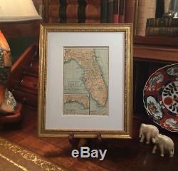
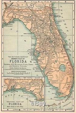
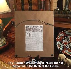


Custom Framed 1896 Map of Florida. Historical Page Attached to the Back of the Frame. Map is in Good condition. No folds, writings, marks, or tears. Original Map Drawn & Engraved by Matthews-Northrup for the 1896 Edition of King's Handbook to the United States; Planned and Edited by Moses King; Text by M.
Sweetser; With Illustrations, Engravings, and Maps; Published 1896 by Matthews Northrup: Buffalo, New York, 1896 ; a copy of the Title Page of which is Included. Framed with Fine Quality Larson-Juhl 1 3/8" Solid Wood Molding with 1 1/2" Archival Matting; Brown Paper Backing with Wire Hanger.
The 1896 Historical & Descriptive Page is Attached to the Back of Frame. Great Map for the Historian or Collector. Makes an Imaginative & Creative Gift.Impressive On Any Home or Office Wall Map Dimensions: 4.5" x 6.5 " Outside Frame Dimensions: 9.5"x10.5" Fine Adornment of Florida History. Top of the Line Larson-Juhl Solid Wood 1 3/8 Scrolled Frame. Great for History & Genealogy, as Map shows Cities, Towns, & Landmarks of 1896, Some of which No Longer Exist Today.
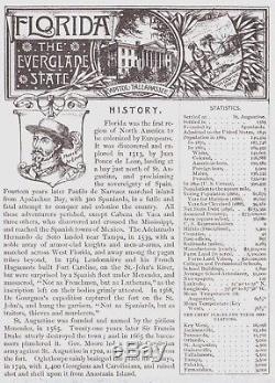
A Few of the Cities, Towns, Railroads, & Other sLandmarks Shown on the Map: Daytona, Jacksonville, Port Orange, Jupiter, Juno, Hypoluxo, Kissimmee, Ocala, Palatka, Baker's Mill, Crawfordville, Matanzas, Crescent Lake, Georgetown, Seville, Eldridge, New Smyrna, Dade City, Lacodchee, Minneola, Windermeree, McKinnon, Campbell, Davenport, Richland, Acton, Lakeland, Plant City, Tamps, San Antonio, Macon, Chipco, Pemberton, Summerville, Blue Springs, Arredondo, Archer, Bronson, Tomoka River, Ormond, Emporia, Huntington, Newnansville, Fort White, High Springs, Pine Mount, Welborn, Jasper, Ellaville, Hudson on the Suwannee, Perry, Quincy, Apalachicola, St. George's Island, Greenwood, Chipley, Ponce De Leon, Cottondale, Marianna, Gordo, Freeport, Escambia, Milton, McDavid, Holt, Muscogee, St. Rochelle, Starke, Hampton, Micanopy, Coconut Grove, Deland, and many others. The 1896 Historical Page on the Back of the Frame Reads: Nickname: The Everglade State. Admitted to the United States: 1845.
Population in 1890: 390,435; Men: 136,444; Women: 133.029. Acres of Farm Land: 3,300,000. Miles of Railroad: 2,283. Colleges and School Buildings:1,800.
Most Populous Cities of 1890 Census: Key West, Jacksonville, Pensacola, Orlando, St. Augustine, Gainesville, Tallahassee, Tampa, Palatka, and Fernandina. Greetings from Historical Savannah, Georgia: Founded 1733.
Some, to beautify their halls, parlors, chambers, & studies... Loveth, getteth, and useth maps, charts, and geographical globes.
John Dee, Advisor to Queen Elizabeth I. The item "Framed Original 1896 Antique Map FLORIDA Cape Coral Boca Raton Clearwater Largo" is in sale since Sunday, December 17, 2017. This item is in the category "Antiques\Maps, Atlases & Globes\North America Maps". The seller is "jonesjackson" and is located in Savannah, Georgia. This item can be shipped worldwide.- Condition: Used
- Original/Reproduction: Antique Original
- Country/Region: United States of America
- Date Range: 1800-1899
- Printing Technique: Lithography
- US State: AL, FL, GA, MS, NC, SC
- Cartographer/Publisher: Matthews Northrup
- Year: 1896
- Type: State Map
- City: Gainesville
- Format: Wall Map

